Weather Event #18: Hartford, WI tornado OR: "What The F*** is Going On?"
Early Sunday afternoon, I was relaxing at my computer, chatting on AIM with Alex Lamers about the standard afternoon summer thunderstorms that were going on. We had just had a brief spurt of heavy rain, with only 1 or 2 rumbles of thunder. The Storm Prediction Center had dropped the 5% ("see text") probabilities for severe wind and hail over southern Wisconsin in their latest outlook update. I was certain that testing out Dad's new outdoor lounge chair would be the highlight of my day:

Then, to my surprise, my NOAA weather radio's alert siren went off shortly before 2:30. I was even more surprised to discover that it was not a severe thunderstorm warning, but a tornado warning:
BULLETIN - EAS ACTIVATION REQUESTED
TORNADO WARNING
NATIONAL WEATHER SERVICE MILWAUKEE/SULLIVAN WI
227 PM CDT SUN JUN 18 2006
THE NATIONAL WEATHER SERVICE IN MILWAUKEE HAS ISSUED A
* TORNADO WARNING FOR...
DODGE COUNTY IN SOUTHEAST WISCONSIN
WASHINGTON COUNTY IN SOUTHEAST WISCONSIN
* UNTIL 315 PM CDT*
AT 226 PM CDT...NATIONAL WEATHER SERVICE DOPPLER RADAR INDICATED A SEVERE THUNDERSTORM CAPABLE OF PRODUCING A TORNADO NEAR HARTFORD... MOVING EAST AT 15 MPH.
* THE TORNADO IS EXPECTED TO BE NEAR... SLINGER AROUND 250 PM CDT... WEST BEND AROUND 300 PM CDT... JACKSON AROUND 310 PM CDT...
THE SAFEST PLACE TO BE DURING A TORNADO IS IN A BASEMENT. GET UNDER A WORKBENCH OR OTHER PIECE OF STURDY FURNITURE. IF NO BASEMENT IS AVAILABLE...SEEK SHELTER ON THE LOWEST FLOOR OF THE BUILDING IN AN INTERIOR HALLWAY OR ROOM SUCH AS A CLOSET. USE BLANKETS OR PILLOWS TO COVER YOUR BODY AND ALWAYS STAY AWAY FROM WINDOWS.
IF IN MOBILE HOMES OR VEHICLES...EVACUATE THEM AND GET INSIDE A SUBSTANTIAL SHELTER. IF NO SHELTER IS AVAILABLE...LIE FLAT IN THE NEAREST DITCH OR OTHER LOW SPOT AND COVER YOUR HEAD WITH YOUR HANDS.
LAT...LON 4344 8849 4321 8849 4321 8808 4342 8808
Events like this are not unprecedented in spring/summer in Wisconsin; when an ordinary thunderstorm briefly develops weak rotation on a day when no severe weather is anticipated, and receives a tornado warning. Usually nothing touches down from these, and any tornado that does develop is very short-lived and weak. I wrote this off as one of those probable false alarms and turned my radio back off, only to have it blare again with my finger still on the button:
BULLETIN - EAS ACTIVATION REQUESTED
TORNADO WARNING
NATIONAL WEATHER SERVICE MILWAUKEE/SULLIVAN WI
228 PM CDT SUN JUN 18 2006
THE NATIONAL WEATHER SERVICE IN MILWAUKEE HAS ISSUED A
* TORNADO WARNING FOR...
SOUTHWEST JEFFERSON COUNTY IN SOUTHEAST WISCONSIN
SOUTHEAST DANE COUNTY IN SOUTH CENTRAL WISCONSIN
* UNTIL 300 PM CDT*
AT 226 PM CDT...TRAINED WEATHER SPOTTERS REPORTED A TORNADO NEAR STOUGHTON...MOVING EAST AT 10 MPH.
* THE TORNADO IS EXPECTED TO BE NEAR... UTICA AROUND 255 PM CDT... ALBION...BUSSEYVILLE AND ROCKDALE AROUND 300 PM CDT
...THE SAFEST PLACE TO BE DURING A TORNADO IS IN A BASEMENT. GET UNDER A WORKBENCH OR OTHER PIECE OF STURDY FURNITURE. IF NO BASEMENT IS AVAILABLE...SEEK SHELTER ON THE LOWEST FLOOR OF THE BUILDING IN AN INTERIOR HALLWAY OR ROOM SUCH AS A CLOSET. USE BLANKETS OR PILLOWS TO COVER YOUR BODY AND ALWAYS STAY AWAY FROM WINDOWS.
IF IN MOBILE HOMES OR VEHICLES...EVACUATE THEM AND GET INSIDE A SUBSTANTIAL SHELTER. IF NO SHELTER IS AVAILABLE...LIE FLAT IN THE NEAREST DITCH OR OTHER LOW SPOT AND COVER YOUR HEAD WITH YOUR HANDS.
LAT...LON 4298 8935 4285 8935 4284 8890 4297 8890
!!!!!!!!!!!!!!!!!!!!!!!!!!!!!!!!!!!!!!!!!!!!!!!!!!!!!!!!!!!!!!!!!!
!!!!!!!!!!!!!!!!!!!!!!!!!!!!!!!!!!!!!!!!!!!!!!!!!!!!!!!!!!!!!!!!!!!!!
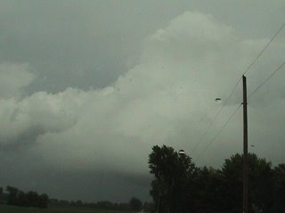
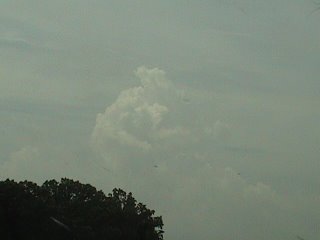
A few seconds later, I could hear the distant wail of the Stoughton sirens as they roared to life for the second time in less than two weeks. I immediately switched my sweatpants for a pair of jeans, popped a tape in my video camera and raced out the door. Once around the tree line I looked to the southwest toward the city of Stoughton, and I could clearly identify the area of "concern". The storm was a mini-supercell, with a low-hanging, dark updraft base that appeared to have several small funnels protruding from it. Even fully zoomed in with my video camera, I could not say for sure if these were rotating. There was some horizonal motion, that is an individual "funnel" would appear to move laterally, and there were little wisps of condensation also drifting slowly along beneath the main cloud base. I could easily see how these could be mistaken for a funnel/tornado especially from a distance. However, radar-indicated rotation was very weak at best and the National Weather Service has not confirmed any tornadoes near Stoughton.
One of several reported "funnels" near Stoughton:


Wider angle view of the storm:

After this, Dad offered to break his Father's Day couch-warming routine and join me on what may be the most impromptu chase ever. We followed the storm's base south toward Edgerton for about an hour and then let it pass by. It continued to look supercellular, although it never developed strong low-level rotation there continued to be pointy appendages as well as clumps of scud drifting around below the base that prompted more reports of funnels and tornadoes.


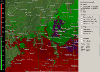
Meanwhile the first tornado warned storm in Dodge and Washington counties did produce a confirmed tornado, an F1 that hit Rubicon and Hartford. The National Weather Service in Milwaukee has put together a page about the tornado with a damage survey, track map, damage photos and tornado photos.
The Doppler radar velocity image (second image below) shows the much stronger rotation with the Hartford storm compared to the Stoughton storm:


Then, to my surprise, my NOAA weather radio's alert siren went off shortly before 2:30. I was even more surprised to discover that it was not a severe thunderstorm warning, but a tornado warning:
BULLETIN - EAS ACTIVATION REQUESTED
TORNADO WARNING
NATIONAL WEATHER SERVICE MILWAUKEE/SULLIVAN WI
227 PM CDT SUN JUN 18 2006
THE NATIONAL WEATHER SERVICE IN MILWAUKEE HAS ISSUED A
* TORNADO WARNING FOR...
DODGE COUNTY IN SOUTHEAST WISCONSIN
WASHINGTON COUNTY IN SOUTHEAST WISCONSIN
* UNTIL 315 PM CDT*
AT 226 PM CDT...NATIONAL WEATHER SERVICE DOPPLER RADAR INDICATED A SEVERE THUNDERSTORM CAPABLE OF PRODUCING A TORNADO NEAR HARTFORD... MOVING EAST AT 15 MPH.
* THE TORNADO IS EXPECTED TO BE NEAR... SLINGER AROUND 250 PM CDT... WEST BEND AROUND 300 PM CDT... JACKSON AROUND 310 PM CDT...
THE SAFEST PLACE TO BE DURING A TORNADO IS IN A BASEMENT. GET UNDER A WORKBENCH OR OTHER PIECE OF STURDY FURNITURE. IF NO BASEMENT IS AVAILABLE...SEEK SHELTER ON THE LOWEST FLOOR OF THE BUILDING IN AN INTERIOR HALLWAY OR ROOM SUCH AS A CLOSET. USE BLANKETS OR PILLOWS TO COVER YOUR BODY AND ALWAYS STAY AWAY FROM WINDOWS.
IF IN MOBILE HOMES OR VEHICLES...EVACUATE THEM AND GET INSIDE A SUBSTANTIAL SHELTER. IF NO SHELTER IS AVAILABLE...LIE FLAT IN THE NEAREST DITCH OR OTHER LOW SPOT AND COVER YOUR HEAD WITH YOUR HANDS.
LAT...LON 4344 8849 4321 8849 4321 8808 4342 8808
Events like this are not unprecedented in spring/summer in Wisconsin; when an ordinary thunderstorm briefly develops weak rotation on a day when no severe weather is anticipated, and receives a tornado warning. Usually nothing touches down from these, and any tornado that does develop is very short-lived and weak. I wrote this off as one of those probable false alarms and turned my radio back off, only to have it blare again with my finger still on the button:
BULLETIN - EAS ACTIVATION REQUESTED
TORNADO WARNING
NATIONAL WEATHER SERVICE MILWAUKEE/SULLIVAN WI
228 PM CDT SUN JUN 18 2006
THE NATIONAL WEATHER SERVICE IN MILWAUKEE HAS ISSUED A
* TORNADO WARNING FOR...
SOUTHWEST JEFFERSON COUNTY IN SOUTHEAST WISCONSIN
SOUTHEAST DANE COUNTY IN SOUTH CENTRAL WISCONSIN
* UNTIL 300 PM CDT*
AT 226 PM CDT...TRAINED WEATHER SPOTTERS REPORTED A TORNADO NEAR STOUGHTON...MOVING EAST AT 10 MPH.
* THE TORNADO IS EXPECTED TO BE NEAR... UTICA AROUND 255 PM CDT... ALBION...BUSSEYVILLE AND ROCKDALE AROUND 300 PM CDT
...THE SAFEST PLACE TO BE DURING A TORNADO IS IN A BASEMENT. GET UNDER A WORKBENCH OR OTHER PIECE OF STURDY FURNITURE. IF NO BASEMENT IS AVAILABLE...SEEK SHELTER ON THE LOWEST FLOOR OF THE BUILDING IN AN INTERIOR HALLWAY OR ROOM SUCH AS A CLOSET. USE BLANKETS OR PILLOWS TO COVER YOUR BODY AND ALWAYS STAY AWAY FROM WINDOWS.
IF IN MOBILE HOMES OR VEHICLES...EVACUATE THEM AND GET INSIDE A SUBSTANTIAL SHELTER. IF NO SHELTER IS AVAILABLE...LIE FLAT IN THE NEAREST DITCH OR OTHER LOW SPOT AND COVER YOUR HEAD WITH YOUR HANDS.
LAT...LON 4298 8935 4285 8935 4284 8890 4297 8890
!!!!!!!!!!!!!!!!!!!!!!!!!!!!!!!!!!!!!!!!!!!!!!!!!!!!!!!!!!!!!!!!!!
!!!!!!!!!!!!!!!!!!!!!!!!!!!!!!!!!!!!!!!!!!!!!!!!!!!!!!!!!!!!!!!!!!!!!
A few seconds later, I could hear the distant wail of the Stoughton sirens as they roared to life for the second time in less than two weeks. I immediately switched my sweatpants for a pair of jeans, popped a tape in my video camera and raced out the door. Once around the tree line I looked to the southwest toward the city of Stoughton, and I could clearly identify the area of "concern". The storm was a mini-supercell, with a low-hanging, dark updraft base that appeared to have several small funnels protruding from it. Even fully zoomed in with my video camera, I could not say for sure if these were rotating. There was some horizonal motion, that is an individual "funnel" would appear to move laterally, and there were little wisps of condensation also drifting slowly along beneath the main cloud base. I could easily see how these could be mistaken for a funnel/tornado especially from a distance. However, radar-indicated rotation was very weak at best and the National Weather Service has not confirmed any tornadoes near Stoughton.
One of several reported "funnels" near Stoughton:


Wider angle view of the storm:

After this, Dad offered to break his Father's Day couch-warming routine and join me on what may be the most impromptu chase ever. We followed the storm's base south toward Edgerton for about an hour and then let it pass by. It continued to look supercellular, although it never developed strong low-level rotation there continued to be pointy appendages as well as clumps of scud drifting around below the base that prompted more reports of funnels and tornadoes.


Meanwhile the first tornado warned storm in Dodge and Washington counties did produce a confirmed tornado, an F1 that hit Rubicon and Hartford. The National Weather Service in Milwaukee has put together a page about the tornado with a damage survey, track map, damage photos and tornado photos.
The Doppler radar velocity image (second image below) shows the much stronger rotation with the Hartford storm compared to the Stoughton storm:


2 Comments:
Greetings from Los Angeles! I enjoyed your entry about the Hartford tornado. I grew up in Hartford, and when I heard about the storm and saw footage, I knew exactly what part of town was hit. I remember MANY instances of horrible storms with the sirens going on. I would actually dread Spring because I knew storm season was coming. Now all I have to deal with are earthquakes. Quite the tradeoff!
Really appreciate the information. I'm a UW-Madison student from Hartford, and for my final weather case study (I'm an atmospheric sciences major) I've decided to research this tornado. Seems like the NWS has decided to eliminate their summary of the event, so I'll end up using your times and warning data. Thanks for posting!
Post a Comment
<< Home