July 27 heavy rain/severe weather event
Early Thursday afternoon my mother and I left for Madison to visit my grandparents at the senior complex on Mineral Point Road; and drove straight into a slow-moving complex of thunderstorms that created havoc all over town. We nearly hydroplaned on the Beltline, then drove through several areas of water that covered 3/4 of our wheels on Park Street, and had to detour around downed power lines on Monroe Street. The end result was that what is normally a 1/2-hour trip took 1 1/2 hours.
The storm also resulted in wind damage and several reports of funnel clouds, including one near Stoughton. However, the National Weather Service has yet to confirm any touchdowns and they issued a statement indicating the likelihood of destructive tornadoes was low:
SPECIAL WEATHER STATEMENT
NATIONAL WEATHER SERVICE MILWAUKEE/SULLIVAN WI
139 PM CDT THU JUL 27 2006
WIZ046-047-051-052-056>060-062>072-272200-
COLUMBIA-DANE-DODGE-FOND DU LAC-GREEN-GREEN LAKE-IOWA-JEFFERSON-KENOSHA-LAFAYETTE-MARQUETTE-MILWAUKEE-OZAUKEE-RACINE-ROCK-SAUK-SHEBOYGAN-WALWORTH-WASHINGTON-WAUKESHA-
139 PM CDT THU JUL 27 2006
...BRIEF FUNNEL CLOUDS POSSIBLE WITH THUNDERSTORMS THIS AFTERNOON...
CONDITIONS ACROSS SOUTH CENTRAL AND SOUTHEAST WISCONSIN ARE FAVORABLE FOR BRIEF FUNNEL CLOUD FORMATIONS WITH THE SCATTERED THUNDERSTORMS THIS AFTERNOON.
THESE TYPES OF FUNNEL CLOUDS NORMALLY DO NOT TOUCH THE GROUND...AND ARE SHORT LIVED. THE ATMOSPHERIC CONDITIONS THESE FUNNELS ARE DEVELOPING IN ARE NOT SUPPORTIVE OF STRONG...DAMAGING TORNADOES.
IN THE RARE CASE THEY DO TOUCH DOWN...THEY SHOULD BE ON THE GROUND ONLY BRIEFLY AND PRODUCE MINIMAL...IF ANY DAMAGE. HOWEVER...IF THREATENING WEATHER CONDITIONS APPROACH YOUR LOCATION...MOVE INDOORS TO A PLACE OF SAFETY.
THE NATIONAL WEATHER SERVICE NEAR SULLIVAN WILL CONTINUE TO CLOSELY MONITOR THE SITUATION.
WOOD
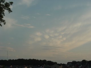
Mammatus clouds from a weakening storm seen on the way home in the evening:
Also hard hit was Waukesha County, where Alex Lamers took several pictures of the wind damage that occurred.
National Weather Service report
The storm also resulted in wind damage and several reports of funnel clouds, including one near Stoughton. However, the National Weather Service has yet to confirm any touchdowns and they issued a statement indicating the likelihood of destructive tornadoes was low:
SPECIAL WEATHER STATEMENT
NATIONAL WEATHER SERVICE MILWAUKEE/SULLIVAN WI
139 PM CDT THU JUL 27 2006
WIZ046-047-051-052-056>060-062>072-272200-
COLUMBIA-DANE-DODGE-FOND DU LAC-GREEN-GREEN LAKE-IOWA-JEFFERSON-KENOSHA-LAFAYETTE-MARQUETTE-MILWAUKEE-OZAUKEE-RACINE-ROCK-SAUK-SHEBOYGAN-WALWORTH-WASHINGTON-WAUKESHA-
139 PM CDT THU JUL 27 2006
...BRIEF FUNNEL CLOUDS POSSIBLE WITH THUNDERSTORMS THIS AFTERNOON...
CONDITIONS ACROSS SOUTH CENTRAL AND SOUTHEAST WISCONSIN ARE FAVORABLE FOR BRIEF FUNNEL CLOUD FORMATIONS WITH THE SCATTERED THUNDERSTORMS THIS AFTERNOON.
THESE TYPES OF FUNNEL CLOUDS NORMALLY DO NOT TOUCH THE GROUND...AND ARE SHORT LIVED. THE ATMOSPHERIC CONDITIONS THESE FUNNELS ARE DEVELOPING IN ARE NOT SUPPORTIVE OF STRONG...DAMAGING TORNADOES.
IN THE RARE CASE THEY DO TOUCH DOWN...THEY SHOULD BE ON THE GROUND ONLY BRIEFLY AND PRODUCE MINIMAL...IF ANY DAMAGE. HOWEVER...IF THREATENING WEATHER CONDITIONS APPROACH YOUR LOCATION...MOVE INDOORS TO A PLACE OF SAFETY.
THE NATIONAL WEATHER SERVICE NEAR SULLIVAN WILL CONTINUE TO CLOSELY MONITOR THE SITUATION.
WOOD
Mammatus clouds from a weakening storm seen on the way home in the evening:

Also hard hit was Waukesha County, where Alex Lamers took several pictures of the wind damage that occurred.
National Weather Service report
posted by Andy at 7:38 PM
0 comments
![]()

