Thursday, June 22, 2006

Dolichovespula arenaria

Accidentally "encountered" this yellowjacket's nest while mowing today. Luckily they weren't too inclined to pursue.


Wednesday, June 21, 2006

June 20, 2006 Storm Chase: Chronicles of a Cap Bust

This appeared to be one of the better tornado setups in the upper Midwest since April. Scott Weberpal had invited me along again; and even though the last few model runs had thrown a few question marks into the mix, we were determined not to repeat the debacle of June 6th and it was all systems go Tuesday morning.

Scott arrived at my house about 8:15 in the morning and we headed to Verona where we met up with Chris Gullikson and transferred to his more spacious van for the long-distance trip.

From there it was a straight shoot westward to the target area in north-central Iowa. We passed through Barneveld, our second encounter with hallowed tornado ground in Wisconsin (the road to and from my house parallels the path of the Stoughton tornado). Close to the Platteville area we began to be overspread by the cirrus, then stratus clouds out ahead of the weakening complex of thunderstorms moving through eastern Iowa. The stratus clouds became quite photogenic as we neared, then crossed the Mississippi River at Dubuque.


Chris (left) and Scott (right) in Chris' chase van:


Approximately halfway between Dubuque and Waterloo, we encountered the rain associated with these thunderstorms. A few nice bolts of cloud-to-ground lightning flashed nearby, but I did not capture them since my video camera was still in its case. I was saving its tapes and battery power for the supercell-fest that appeared likely to unfold late in the afternoon into the evening. :-)

After a quick gas stop and lunch at Subway in overcast, rainy Evansdale, IA (a suburb of Waterloo) it was a non-stop drive to the initial target of Webster City in north-central Iowa, a little bit west of due north of Des Moines. We arrived there shortly before 2 PM and discovered a wifi hotspot next to a park, so we pulled over and Chris and Scott began pouring over every piece of available model, mesoanalysis, satellite and radar data while I observed intently over their shoulders.

The new mesoanalysis data and model runs were painting a confusing picture. The sky had cleared following the earlier round of showers and storms, but we were still in the cool sector well north of the warm front. The front had been expected to move north to near the Iowa/Minnesota border and serve as a focus for moisture pooling and thunderstorm initiation later in the afternoon. However, that front now appeared to have stalled over southwest Iowa, perhaps reenforced by outflow from the old storms. Meanwhile, the near-term RUC (Rapid Update Cycle) model wanted to veer the surface winds over most of Iowa to southwesterly by the evening, which would reduce surface convergence and hence the chances of new thunderstorm development. Also there was the little matter of the 10C H7 temperature line, which was analyzed by the mesoanalysis to be retreating westward, but the RUC insisted on planting it in eastern Iowa by 00z (7 PM). If correct, this meant warm temperatures at the mid-levels of the atmosphere that would also impede thunderstorm development.

As we mulled over these less-than-encouraging developments, we were joined by Doug Raflik and Todd Sprinkmann. We all clustered around the laptop computers, constantly refreshing the mesoanalysis and satellite loops, hoping something would jump out and provide a clue as to where to go from here. That was getting us nowhere, but luckily Doug and Todd had brought a foam-rubber football for amusement.

Scott drops back to pass:


Chris (left) and Doug (right):


Todd searches for a weakness in the defense:


We hung around the park for a good 3+ hours. In between catch sessions, we would run back to the vans to see if the analysis updates would make a target jump out at us, or if the Storm Prediction Center would issue a mesoscale discussion, or just something, ANYTHING that would provide a clue as to where the heck to go. Maybe we needed to get a better spiral on the football to induce some vorticity in the air. It gradually became more humid as the warm front neared, but it also clouded up again as isentropic lift on the warm front touched off weak, elevated showers and thunderstorms to its north-another potential wrench in the supercell machine.

Todd scans the atmosphere with his handheld anemometer/thermometer/hygrometer:


Scott and Todd compare dewpoint readings. Talk about your mesoscale boundaries!


After waiting around at the park for 3 1/2 hours, a ray of hope came at last at 5:20 PM in the form of a mesoscale discussion from the SPC, indicating that supercells and tornadoes were still possible across central and eastern Iowa. The md highlighted an area a bit east of where we were, and not wanting to be behind west-to-east moving storms we decided to head that way. Finally the chase was on...or was it? Chris turned the key in his van only to discover that the battery was dying and it wouldn't start! After taking about 10-15 minutes to jump start it from Doug's van, we said goodbye to Webster City.

We drove east the way we came, out of Webster City and toward Waterloo. The sky still did not look promising, with very little cumulus development. As the evening wore on it became apparent that the warm temperatures aloft were winning, so we just continued on home. Pushing into eastern Iowa, we encountered the only thunderstorm around, a small, lone cell that was making a valiant but ultimately futile attempt to overcome the cap. Like the morning storms, some light rain and a couple of lightning strikes were all it could muster. Then, as the setting sun to the west shone against the rain shafts of the storm, two spectacular rainbows appeared, one on either side of the highway.

These are of the one to the left (north) of the road. My pictures, taken from the backseat are not that great. Scott also got his camera out and I would expect his are better. I did not get still photos of the other rainbow to the south, although I did take video of it and might post a capture if I feel like it.


A picture of the sun dropping behind the clouds, made blurred by the long exposure time required by the low light as we move at 65 mph down the highway.


So much for long-distance chase #1. I didn't particularily expect to see tornadoes but I also did not expect a complete cap bust! However, I'd have felt worse sitting at home watching radar of supercells popping up all over Iowa, which given the conditions forecast by the earlier model runs was definitely within the realm of possibility. It was also fun to get out on the road and meet some of Wisconsin's veteran chasers. Chases like this seem to have been the rule for most of May and June 2006. Either the atmosphere finds some way to screw up a nice looking situation, or the situation looks so bad that nobody plans on chasing it, and it produces tornadoes (a la June 6 and 18).

Monday, June 19, 2006

Weather Event #18: Hartford, WI tornado OR: "What The F*** is Going On?"

Early Sunday afternoon, I was relaxing at my computer, chatting on AIM with Alex Lamers about the standard afternoon summer thunderstorms that were going on. We had just had a brief spurt of heavy rain, with only 1 or 2 rumbles of thunder. The Storm Prediction Center had dropped the 5% ("see text") probabilities for severe wind and hail over southern Wisconsin in their latest outlook update. I was certain that testing out Dad's new outdoor lounge chair would be the highlight of my day:


Then, to my surprise, my NOAA weather radio's alert siren went off shortly before 2:30. I was even more surprised to discover that it was not a severe thunderstorm warning, but a tornado warning:

BULLETIN - EAS ACTIVATION REQUESTED
TORNADO WARNING
NATIONAL WEATHER SERVICE MILWAUKEE/SULLIVAN WI
227 PM CDT SUN JUN 18 2006

THE NATIONAL WEATHER SERVICE IN MILWAUKEE HAS ISSUED A

* TORNADO WARNING FOR...

DODGE COUNTY IN SOUTHEAST WISCONSIN
WASHINGTON COUNTY IN SOUTHEAST WISCONSIN

* UNTIL 315 PM CDT*

AT 226 PM CDT...NATIONAL WEATHER SERVICE DOPPLER RADAR INDICATED A SEVERE THUNDERSTORM CAPABLE OF PRODUCING A TORNADO NEAR HARTFORD... MOVING EAST AT 15 MPH.

* THE TORNADO IS EXPECTED TO BE NEAR... SLINGER AROUND 250 PM CDT... WEST BEND AROUND 300 PM CDT... JACKSON AROUND 310 PM CDT...

THE SAFEST PLACE TO BE DURING A TORNADO IS IN A BASEMENT. GET UNDER A WORKBENCH OR OTHER PIECE OF STURDY FURNITURE. IF NO BASEMENT IS AVAILABLE...SEEK SHELTER ON THE LOWEST FLOOR OF THE BUILDING IN AN INTERIOR HALLWAY OR ROOM SUCH AS A CLOSET. USE BLANKETS OR PILLOWS TO COVER YOUR BODY AND ALWAYS STAY AWAY FROM WINDOWS.

IF IN MOBILE HOMES OR VEHICLES...EVACUATE THEM AND GET INSIDE A SUBSTANTIAL SHELTER. IF NO SHELTER IS AVAILABLE...LIE FLAT IN THE NEAREST DITCH OR OTHER LOW SPOT AND COVER YOUR HEAD WITH YOUR HANDS.

LAT...LON 4344 8849 4321 8849 4321 8808 4342 8808

Events like this are not unprecedented in spring/summer in Wisconsin; when an ordinary thunderstorm briefly develops weak rotation on a day when no severe weather is anticipated, and receives a tornado warning. Usually nothing touches down from these, and any tornado that does develop is very short-lived and weak. I wrote this off as one of those probable false alarms and turned my radio back off, only to have it blare again with my finger still on the button:

BULLETIN - EAS ACTIVATION REQUESTED
TORNADO WARNING
NATIONAL WEATHER SERVICE MILWAUKEE/SULLIVAN WI
228 PM CDT SUN JUN 18 2006

THE NATIONAL WEATHER SERVICE IN MILWAUKEE HAS ISSUED A

* TORNADO WARNING FOR...

SOUTHWEST JEFFERSON COUNTY IN SOUTHEAST WISCONSIN
SOUTHEAST DANE COUNTY IN SOUTH CENTRAL WISCONSIN

* UNTIL 300 PM CDT*

AT 226 PM CDT...TRAINED WEATHER SPOTTERS REPORTED A TORNADO NEAR STOUGHTON...MOVING EAST AT 10 MPH.

* THE TORNADO IS EXPECTED TO BE NEAR... UTICA AROUND 255 PM CDT... ALBION...BUSSEYVILLE AND ROCKDALE AROUND 300 PM CDT

...THE SAFEST PLACE TO BE DURING A TORNADO IS IN A BASEMENT. GET UNDER A WORKBENCH OR OTHER PIECE OF STURDY FURNITURE. IF NO BASEMENT IS AVAILABLE...SEEK SHELTER ON THE LOWEST FLOOR OF THE BUILDING IN AN INTERIOR HALLWAY OR ROOM SUCH AS A CLOSET. USE BLANKETS OR PILLOWS TO COVER YOUR BODY AND ALWAYS STAY AWAY FROM WINDOWS.

IF IN MOBILE HOMES OR VEHICLES...EVACUATE THEM AND GET INSIDE A SUBSTANTIAL SHELTER. IF NO SHELTER IS AVAILABLE...LIE FLAT IN THE NEAREST DITCH OR OTHER LOW SPOT AND COVER YOUR HEAD WITH YOUR HANDS.

LAT...LON 4298 8935 4285 8935 4284 8890 4297 8890

!!!!!!!!!!!!!!!!!!!!!!!!!!!!!!!!!!!!!!!!!!!!!!!!!!!!!!!!!!!!!!!!!!
!!!!!!!!!!!!!!!!!!!!!!!!!!!!!!!!!!!!!!!!!!!!!!!!!!!!!!!!!!!!!!!!!!!!!

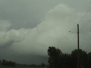
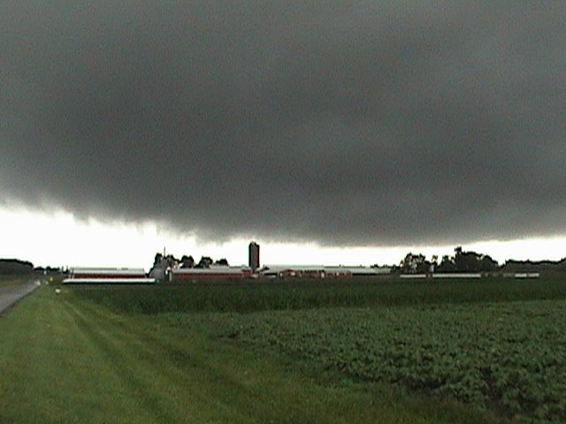
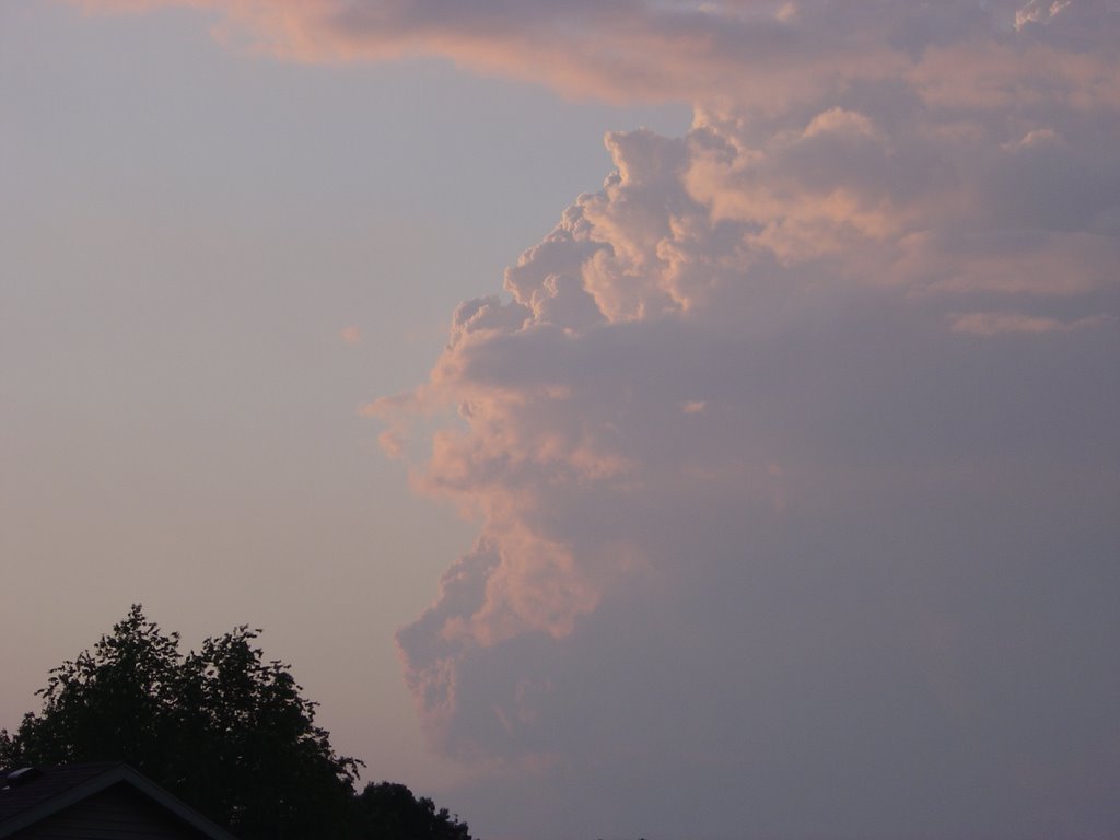
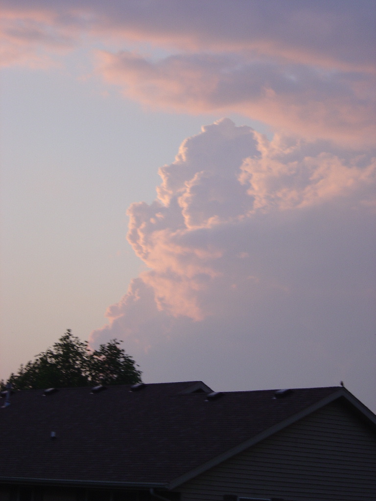
A few seconds later, I could hear the distant wail of the Stoughton sirens as they roared to life for the second time in less than two weeks. I immediately switched my sweatpants for a pair of jeans, popped a tape in my video camera and raced out the door. Once around the tree line I looked to the southwest toward the city of Stoughton, and I could clearly identify the area of "concern". The storm was a mini-supercell, with a low-hanging, dark updraft base that appeared to have several small funnels protruding from it. Even fully zoomed in with my video camera, I could not say for sure if these were rotating. There was some horizonal motion, that is an individual "funnel" would appear to move laterally, and there were little wisps of condensation also drifting slowly along beneath the main cloud base. I could easily see how these could be mistaken for a funnel/tornado especially from a distance. However, radar-indicated rotation was very weak at best and the National Weather Service has not confirmed any tornadoes near Stoughton.

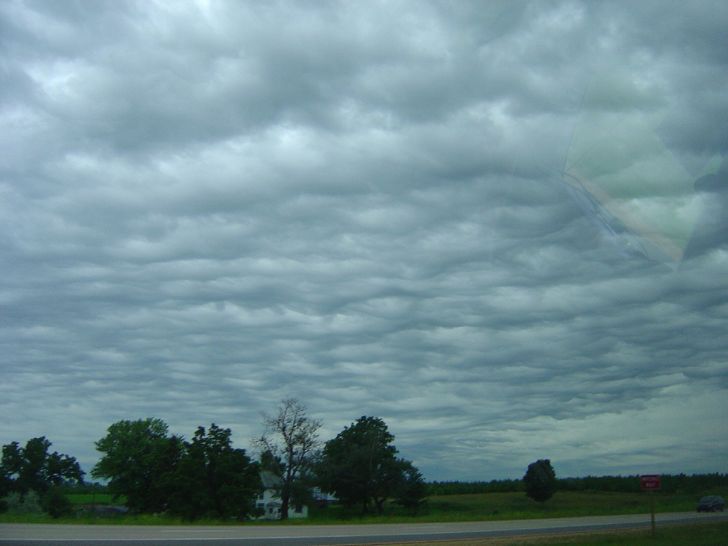
One of several reported "funnels" near Stoughton:


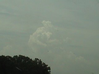
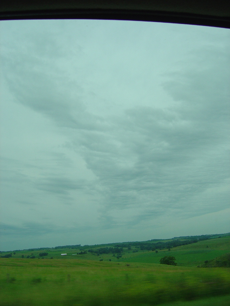
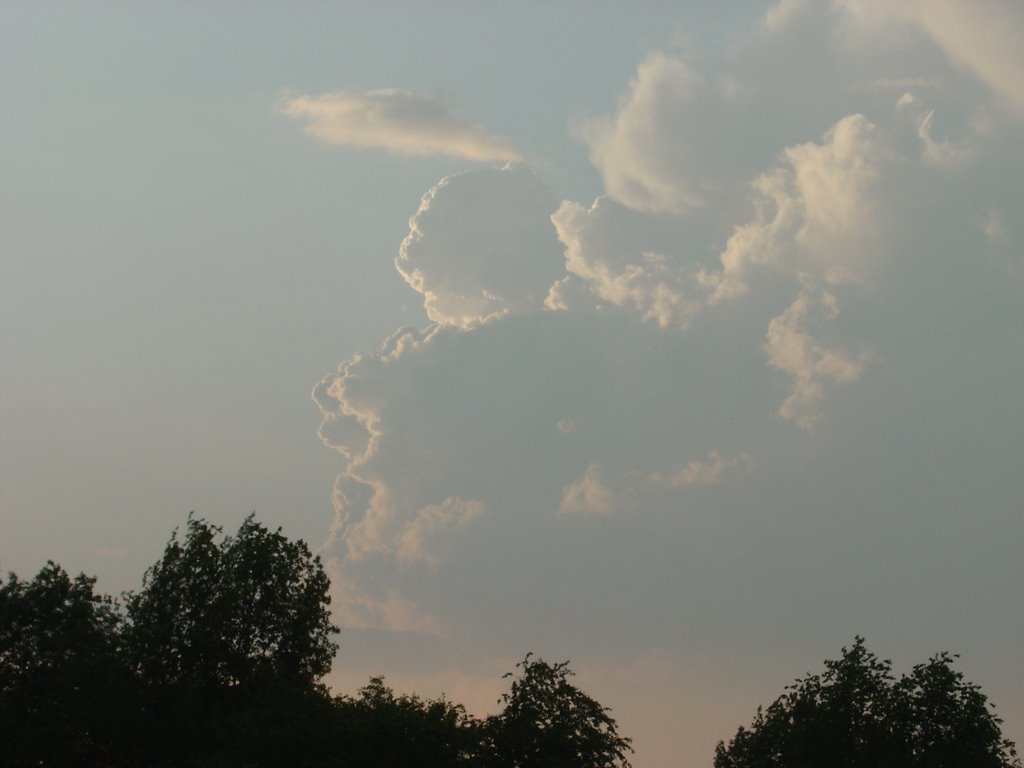
Wider angle view of the storm:


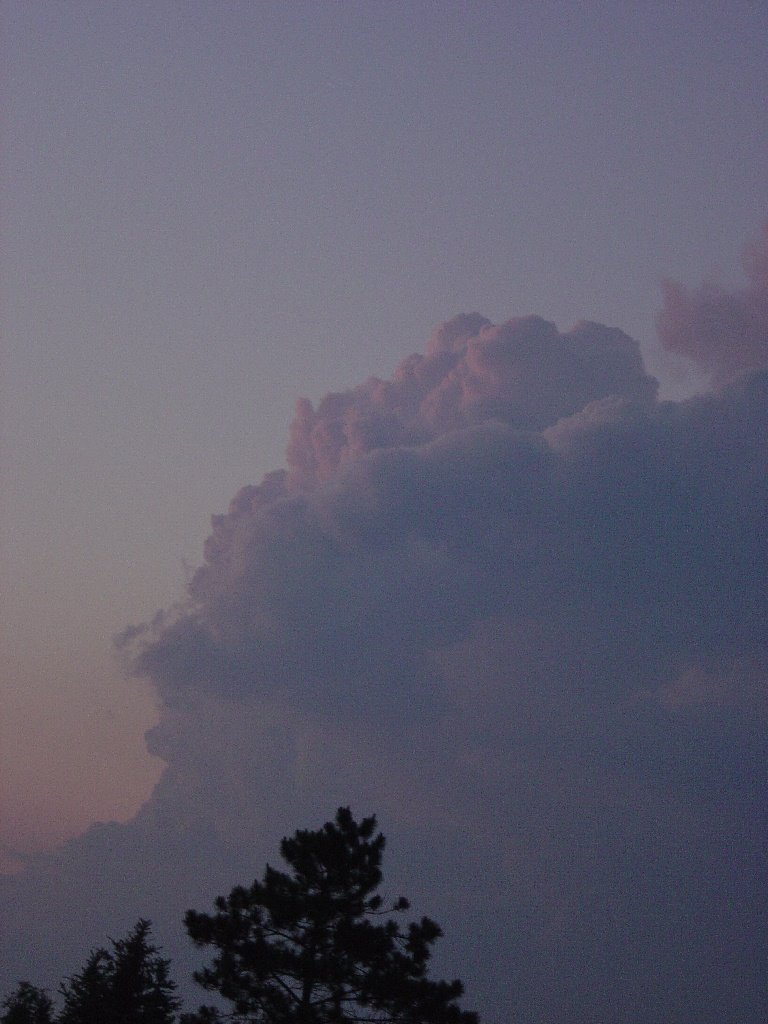
After this, Dad offered to break his Father's Day couch-warming routine and join me on what may be the most impromptu chase ever. We followed the storm's base south toward Edgerton for about an hour and then let it pass by. It continued to look supercellular, although it never developed strong low-level rotation there continued to be pointy appendages as well as clumps of scud drifting around below the base that prompted more reports of funnels and tornadoes.


Meanwhile the first tornado warned storm in Dodge and Washington counties did produce a confirmed tornado, an F1 that hit Rubicon and Hartford. The National Weather Service in Milwaukee has put together a page about the tornado with a damage survey, track map, damage photos and tornado photos.

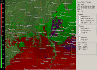
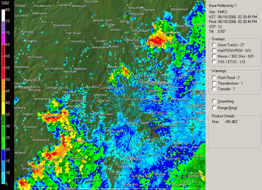
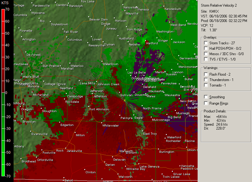
The Doppler radar velocity image (second image below) shows the much stronger rotation with the Hartford storm compared to the Stoughton storm:


Friday, June 09, 2006

Abu Musab al-Zarqawi

There was a man in Iraq who was causin' lots of trouble
So America's Great Leader went for him on the double
Said "The liberals and the Dems don't think I can;
You just watch me now, I'll get my man"

So they looked high and they looked low
and they took him out with the bomb's mighty blow
They were determined to collect that bounty on his head
Finally good news from Iraq, for al-Zarqawi's dead

The President met with his men that night
to plot how he would keep up the fight
He said "Well done boys, you've really earned your pay,
now find me bin Laden right before Election Day!"

-ARW 6/09/06

Thursday, June 08, 2006

Weather Event #17-June 6 Wisconsin Tornadoes

Three tornadoes developed across south-central Wisconsin on Tuesday, June 6. Wind profiles and instability were not particularily impressive, as indicated in the forecast for the day; but they proved to be adequate and with low LCL heights (small temperature-dewpoint spreads resulting in lower cloud bases) tornadoes were able to develop. The Columbia County tornado was quite large and long-lived and its F1 rating may be an underestimate of its true strength, especially if it did not encounter any well-constructed/well-anchored buildings.

NWS Milwaukee/Sullivan, WI
Doug Raflik's chase pictures: 1 2 3
Scott Weberpal's chase pictures: 1 2 3

I took these pictures of a cumulonimbus cloud looking north from my neighborhood at about the time a tornado was reported unroofing a house near Waunakee. This tornado was not confirmed, so the damage may have been caused by straight-line thunderstorm winds.


As as aside, Stoughton's EMS must be paranoid after last August 18th. They blew the sirens twice Tuesday night; once for each tornado warning issued for Dane County, even though neither storm remotely threatened the Stoughton area.