Tuesday, May 30, 2006

Preliminary pictures from May 24, 2006 Storm Chase

Last Wednesday, May 24, 2006; I had the opportunity to go on my first-ever real storm chase. Jim Westover, his girlfriend Leslie, and I chased a line of severe storms across south-central Wisconsin; from Stoughton to Janesville to Whitewater. Alex Lamers provided nowcasting for us via cell phone.

I will be putting together a complete web page about this on my weather site within the next few days. For now here is a sampling of what we saw:

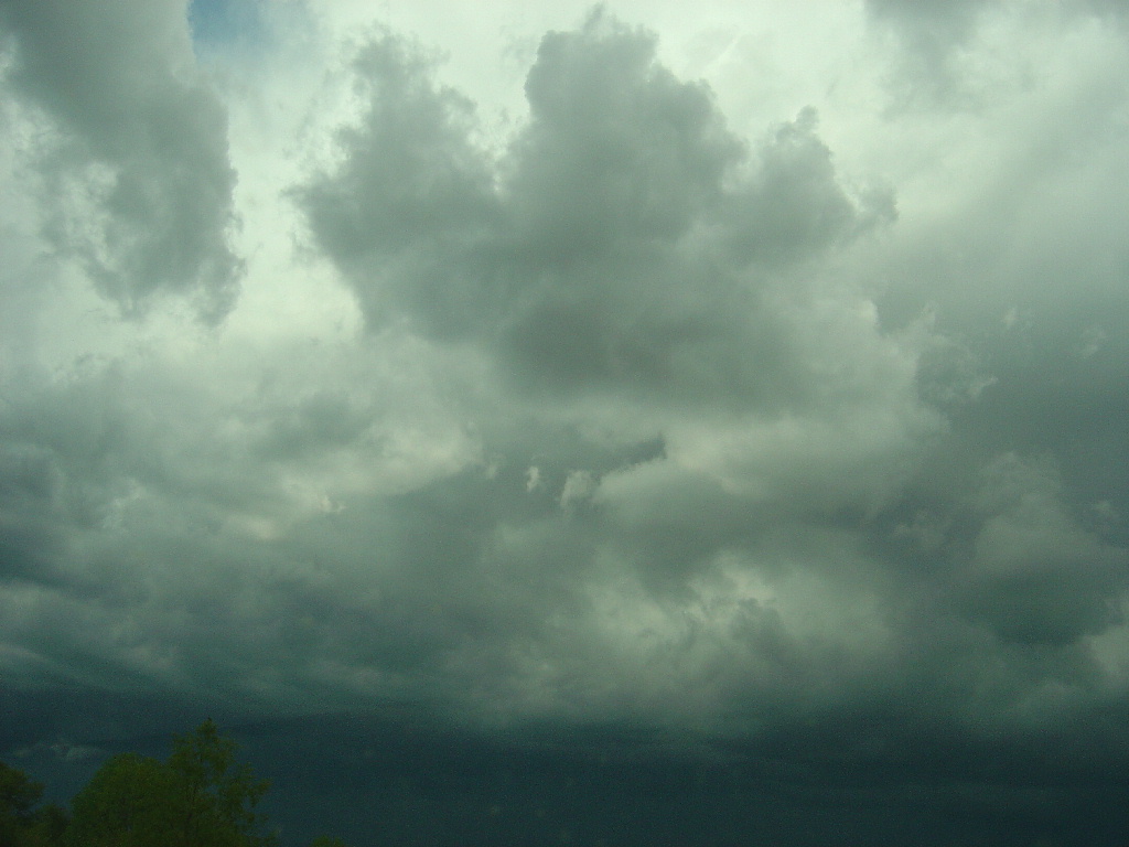
Shelf cloud near the I-90/Highway N interchange. We received outflow winds of about 40-45 mph as this passed over; raising a dust cloud in a dirt driveway to our south.


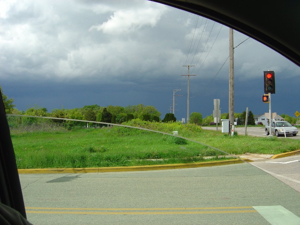
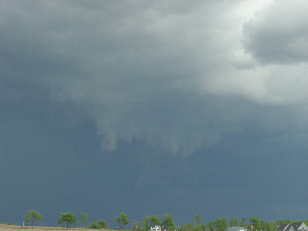
From this point we took I-90 south toward Edgerton and stopped at another truck stop northeast of town on Highway 59; trying unsucessfully to get Jim's laptop to connect to the wireless network they supposedly had. We were just ahead of the shelf cloud and the winds were beginning to pick up again. Alex informed us that radar indicated an area of rotation embedded in the squall line and heading our way. We turned around to face west so we could see what was coming at us, and saw this:


I am still not 100% positive what this feature was; like the lowering I saw on May 17th it was not clearly a shelf cloud and not clearly a wall cloud. I could not distinguish rotation in real time and I will have to do a thorough video analysis.

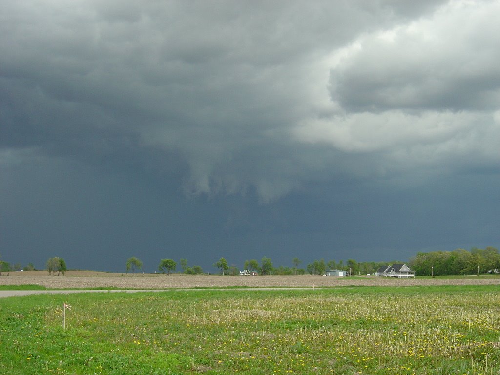
Driving southwest into Edgerton we saw this lowering which looked more like a classic wall cloud. This image is lousy because of the powerlines and streetlight; but we drove right up to this later and observed scud clouds rising into it.


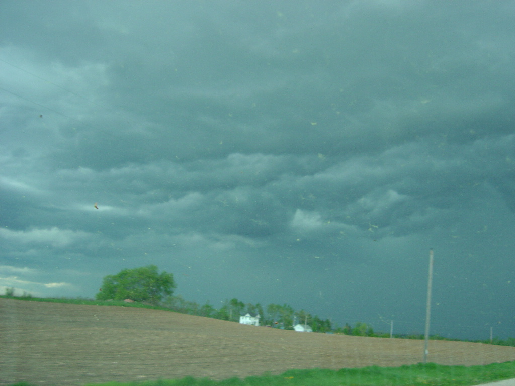
From Edgerton we headed south to Janesville and then attempted to get ahead of the storm by driving northeast through Milton to Whitewater; back on Highway 59. From Whitewater we took Highway 89 south by about four miles. During this entire journey we were enveloped in a nearly blinding rainstorm as the cells on the end of the squall line began to congeal and quashed any slight remaining possibility of tornadic storms. We finally began to regain visibility as the line of storms passed and revealed a beautiful sunset to the west:


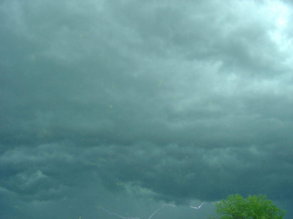
Meanwhile, the squall line raged on to the east with torrential rain; brilliant lightning and a nice display of mammatus clouds:


A day that began like any other storm day ended up as my first chase; and I had a blast! Thanks to Jim and Leslie for a great chase experience and to Alex Lamers for some excellent nowcasting, especially considering he was without the Milwaukee/Sullivan radar which crashed during the storms!

Monday, May 22, 2006

Waspishness-Installment 3

The Cotoneaster continues to hum with insects; some flies, bumblebees and solitary bees but its most frequent customers remain the social wasps.

Queen eastern yellowjacket, Vespula maculifrons:


Queen German yellowjacket, Vespula germanica:


Sunday, May 21, 2006

Things That Go Buzz in the Garden-Installment 2

This is a newly started nest of the bald-faced hornet (Dolichovespula maculata). It is attached to the roof eaves on the garage at the house in Madison that my family moved out of seven years ago and still owns. At this stage it looks exactly like a Polistes wasp nest except for the golfball-sized paper cover over the comb; and the founding queen is the only adult hornet in the nest.


Wednesday, May 17, 2006

Weather Event #15-May 17 Wisconsin Storms

Wednesday, May 17 was Wisconsin's first notable severe thunderstorm day since April 13. I observed the leading edge of an approaching severe storm just northeast of Stoughton between 3:00 and 3:30 PM. The storm did not produce severe weather at my location, although a news report said trees were downed in Stoughton. If so, no local storm report was issued for the event. However hail and wind damage were reported in the Madison and Janesville areas from the same storm complex.


Ominous-looking cloud lowering. Judging from its location in the storm it was probably an outflow cloud, even though it doesn't look like a classic shelf cloud. It probably gave residents quite a fright though as it hovered directly over areas affected by a major tornado on August 18, 2005.


The lightning was a lucky shot:


BULLETIN - EAS ACTIVATION REQUESTED
SEVERE THUNDERSTORM WARNING
NATIONAL WEATHER SERVICE MILWAUKEE/SULLIVAN WI
326 PM CDT WED MAY 17 2006

THE NATIONAL WEATHER SERVICE IN MILWAUKEE HAS ISSUED A

* SEVERE THUNDERSTORM WARNING FOR...
WESTERN JEFFERSON COUNTY IN SOUTHEAST WISCONSIN
EASTERN DANE COUNTY IN SOUTH CENTRAL WISCONSIN

* UNTIL 415 PM CDT*

AT 322 PM CDT...NATIONAL WEATHER SERVICE DOPPLER RADAR INDICATED A SEVERE THUNDERSTORM CAPABLE OF PRODUCING NICKEL SIZE HAIL...AND DAMAGING WINDS IN EXCESS OF 60 MPH. THIS STORM WAS LOCATED NEAR COTTAGE GROVE...OR ABOUT 7 MILES EAST OF MCFARLAND...AND MOVING SOUTHEAST AT 25 MPH.

* THE SEVERE THUNDERSTORM WILL BE NEAR... CAMBRIDGE...LAKE RIPLEY AND LAKE MILLS AROUND 340 PM CDT...
JEFFERSON AROUND 350 PM CDT...
FORT ATKINSON AROUND 400 PM CDT...

THIS IS A DANGEROUS STORM. IF YOU ARE IN ITS PATH...PREPARE IMMEDIATELY FOR DAMAGING WINDS...DESTRUCTIVE HAIL...AND DEADLY CLOUD TO GROUND LIGHTNING. PEOPLE OUTSIDE SHOULD MOVE TO A SHELTER...PREFERABLY INSIDE A STRONG BUILDING BUT AWAY FROM WINDOWS.

LAT...LON 4319 8907 4305 8931 4285 8913 4285 8878
4318 8883

MK

PRELIMINARY LOCAL STORM REPORT...SUMMARY
NATIONAL WEATHER SERVICE MILWAUKEE/SULLIVAN WI
941 PM CDT WED MAY 17 2006

..TIME... ...EVENT... ...CITY LOCATION... ...LAT.LON.....DATE... ....MAG.... ..COUNTY LOCATION..ST.. ...SOURCE.... ..REMARKS..

0125 PM HAIL WAUKESHA 43.01N 88.24W 05/17/2006 M0.25 INCH WAUKESHA WI NWS EMPLOYEE

0141 PM HAIL 1 NNE GREENFIELD 42.98N 88.00W 05/17/2006 E0.25 INCH MILWAUKEE WI TRAINED SPOTTER

0215 PM HAIL JEFFERSON 43.01N 88.81W 05/17/2006 M0.25 INCH JEFFERSON WI TRAINED SPOTTER

0222 PM TSTM WND GST SHEBOYGAN 43.75N 87.73W 05/17/2006 M43.00 MPH SHEBOYGAN WI ASOS

0223 PM HAIL SHEBOYGAN 43.75N 87.73W 05/17/2006 M0.25 INCH SHEBOYGAN WI LAW ENFORCEMENT

0239 PM HAIL PLYMOUTH 43.75N 87.97W 05/17/2006 M1.75 INCH SHEBOYGAN WI TRAINED SPOTTER

0249 PM HAIL 4 WNW CASCADE 43.68N 88.08W 05/17/2006 E0.75 INCH SHEBOYGAN WI PUBLIC ESTIMATED 0.75 INCH DIAMETER HAIL IN THE TOWNSHIP OF MITCHELL.

0258 PM HAIL DEFOREST 43.25N 89.35W 05/17/2006 M1.75 INCH DANE WI TRAINED SPOTTER

0302 PM HAIL DEFOREST 43.25N 89.35W 05/17/2006 E0.75 INCH DANE WI FIRE DEPT/RESCUE ESTIMATED 0.75 INCH DIAMETER HAIL AT INTERSECTION OF HOLUM AND MAIN STREETS.

0309 PM HAIL BEAVER DAM 43.46N 88.84W 05/17/2006 E0.50 INCH DODGE WI TRAINED SPOTTER REPORTED ON THE WEST SIDE OF BEAVER DAM LAKE.

0319 PM HAIL MADISON 43.08N 89.39W 05/17/2006 M0.50 INCH DANE WI ASOS

0325 PM HAIL 1 W MADISON 43.08N 89.41W 05/17/2006 E0.50 INCH DANE WI CO-OP OBSERVER ESTIMATED 0.50 INCH DIAMETER HAIL COVERING THE GROUND AT THE UW MADISON ATMOSPHERIC AND OCEANIC SCIENCES BUILDING. OTHER REPORTS OF 0.50 INCH DIAMETER HAIL WERE RECEIVED IN THE MADISON AREA.

0332 PM HAIL 1 SSW WAUNAKEE 43.17N 89.46W 05/17/2006 M0.50 INCH DANE WI AMATEUR RADIO MEASURED 0.50 INCH DIAMETER HAIL 0.75 MILES SSW OF WAUNAKEE.

0401 PM TSTM WND GST JANESVILLE 42.68N 89.02W 05/17/2006 E65.00 MPH ROCK WI PUBLIC ESTIMATED 65 MPH WIND GUST ON THE NORTH SIDE OF JANESVILLE.

0401 PM FUNNEL CLOUD MILWAUKEE 43.06N 87.97W 05/17/2006 MILWAUKEE WI OFFICIAL NWS OBS REPORTED BY FAA CONTRACT WEATHER OBSERVER AND TOWER PERSONNEL AT MILWAUKEE/S MITCHELL INTERNATIONAL AIRPORT.

0402 PM HAIL MILWAUKEE 43.06N 87.97W 05/17/2006 E0.25 INCH MILWAUKEE WI TRAINED SPOTTER REPORTED IN DOWNTOWN MILWAUKEE.

0405 PM HAIL HARTLAND 43.10N 88.34W 05/17/2006 E1.00 INCH WAUKESHA WI PUBLIC ESTIMATED 1.00 INCH DIAMETER HAIL IN HARTLAND. SOME CRACKED WINDSHIELDS AND DENTS IN CARS.

0405 PM HAIL 1 W RACINE 42.73N 87.83W 05/17/2006 E0.88 INCH RACINE WI AMATEUR RADIO

0410 PM TSTM WND GST SHOPIERE 42.50N 88.73W 05/17/2006 E45.00 MPH WALWORTH WI TRAINED SPOTTER

0410 PM TSTM WND DMG JANESVILLE 42.68N 89.02W05/17/2006 ROCK WI LAW ENFORCEMENT A FEW TREES DOWN ON HIGHWAY 11 NEAR AVALON AND EMERALD GROVE SOUTHEAST OF JANESVILLE.

0425 PM FUNNEL CLOUD RACINE 42.73N 87.81W 05/17/2006 RACINE WI FIRE DEPT/RESCUE REPORTED AT TAYLOR ST AND 17TH ST 2 MILES WEST OF LAKE MICHIGAN.

0427 PM FUNNEL CLOUD RACINE 42.73N 87.81W 05/17/2006 RACINE WI PUBLIC REPORTED AT 7TH AND MAIN ST. 1 MILE WEST OF LAKE.

0430 PM HAIL WATERTOWN 43.19N 88.72W 05/17/2006 E0.50 INCH JEFFERSON WI LAW ENFORCEMENT REPORTED AT THE INTERSECTION HIGHWAYS D AND E.

0445 PM HAIL RACINE 42.73N 87.81W 05/17/2006 E0.50 INCH RACINE WI PUBLIC ESTIMATED 0.50 INCH DIAMETER HAIL AT SAINT MARY HOSPITAL IN RACINE. SMALL DENTS FOUND IN SIDE AND TOP OF VEHICLE AND ON ALUMINUM SIDING OF HOUSE IN RACINE.

WOOD

What's buzzin' lately

These are "gyne", or egg-laying female paper wasps, Polistes species; on their incipient nests. The first nest is located in a corner under the roof eaves of the house. The second is located inside the cavity formed at the corner of the deck railing.


Paper wasps collecting loose wood fibers off the deck surface to make their nests:


This queen aerial yellowjacket, Dolichovespula arenaria, partakes of some nectar from the Cotoneaster bush out back. In theory, all female paper wasps are capable of laying viable eggs, although only a select few do. In yellowjackets, there are distinct worker and queen castes and only the queens can lay fully viable eggs.


This is a queen eastern yellowjacket, Vespula maculifrons, also feeding from the Cotoneaster. Aerial yellowjackets get their name because they usually build nests aboveground. Their nests are very similar to the bald-faced hornet nests like that pictured a few posts down. Eastern yellowjackets and German yellowjackets (farther down in this post) nest in the ground, hollow stumps, or wall voids.


Head-on view of a queen German yellowjacket, Vespula germanica. The three black spots on the face are diagnostic character of this species.

Friday, May 12, 2006

Moving Day

Time to move out from Apartment B-4 at UWGB that has been my home since September, 2005.

My bedroom before the packing starts:


During:


After:


Jayme (my roommate and R.A.) cooks himself something in the kitchen:

Thursday, May 11, 2006

Weather Event #14-May 11 Wisconsin Wind Storm

A powerful low pressure system centered over Michigan brought rain and strong winds to much of Wisconsin on Thursday. Winds gusted to near 50 mph at times, causing sporadic minor damage. Power was knocked out at UWGB from about 8:15 to 10:00 PM.

National radar loop. The circulation resembles that of a tropical storm.


Minor damage around campus. I'm not sure what this post with the electrical wires and box was for, but it came down several hours before the power outage. Most of the tree branches that came down were only about 1/2" thick, with the exception of a couple that were near 1".


PRELIMINARY LOCAL STORM REPORT
NATIONAL WEATHER SERVICE GREEN BAY WI
1128 AM CDT THU MAY 11 2006..

TIME... ...EVENT... ...CITY LOCATION... ...LAT.LON...
...DATE... ....MAG.... ..COUNTY LOCATION..ST.. ...SOURCE....
..REMARKS..

1115 AM NON-TSTM WND DMG GREEN BAY 44.51N 88.00W 05/11/2006 BROWN WI TRAINED SPOTTER
18 INCH DIAMETER TREE SPLIT IN TWO. WIND GUST TO 49 MPH AT GREEN BAY ASOS.

1050 AM NON-TSTM WND GST GILLS ROCK 45.28N 87.01W 05/11/2006 M70 MPH DOOR WI MESONET

0942 AM NON-TSTM WND GST SISTER BAY 45.18N 87.11W 05/11/2006 M66 MPH DOOR WI MESONET
TREES AND POWER LINES ARE DOWN ACROSS DOOR COUNTY.


PRELIMINARY LOCAL STORM REPORT
NATIONAL WEATHER SERVICE GREEN BAY WI
124 PM CDT THU MAY 11 2006

..TIME... ...EVENT... ...CITY LOCATION... ...LAT.LON...
...DATE... ....MAG.... ..COUNTY LOCATION..ST.. ...SOURCE....
..REMARKS..

1225 PM NON-TSTM WND DMG PEMBINE 45.63N 88.00W 05/11/2006 MARINETTE WI AMATEUR RADIO
TREE DOWN.

1230 PM NON-TSTM WND DMG 1 S MARINETTE 45.08N 87.61W 05/11/2006 MARINETTE WI AMATEUR RADIO
TREE DOWN BLOCKING ROAD.

1230 PM NON-TSTM WND DMG 8 W MARINETTE 45.09N 87.77W 05/11/2006 MARINETTE WI AMATEUR RADIO
TREE DOWN BLOCKING ROAD.

1230 PM NON-TSTM WND DMG 1 N WAUSAUKEE 45.37N 87.94W 05/11/2006 MARINETTE WI AMATEUR RADIO ***1INJ*** FALLEN TREE WITH A SERIOUS INJURY


KURIMSKI


PUBLIC INFORMATION STATEMENT
NATIONAL WEATHER SERVICE GREEN BAY WI
455 PM CDT THU MAY 11 2006

...AN INTENSE STORM SYSTEM BRINGS HEAVY RAINS AND STRONG WINDS TO THE REGION...

AN INTENSE STORM SYSTEM MOVING ACROSS WESTERN LOWER MICHIGAN BROUGHT HEAVY RAINS AND GUSTY WINDS TO THE AREA TODAY. HERE IS A LIST OF PRECIP AMOUNTS AND PEAK WIND REPORTS THROUGH 4 PM.

------------------------------------------------------------------------
CITY COUNTY WIND(MPH) PRECIP(IN)

GILLS ROCK(MARINE) DOOR 70 MPH M
SISTER BAY(MARINE) DOOR 66 MPH M
ALGOMA(MARINE) KEWAUNEE 52 MPH M
STURGEON BAY DOOR 55 MPH 1.65
PLOVER PORTAGE 51 MPH 0.82
GREEN BAY(NWS) BROWN 49 MPH 1.09
MARSHFIELD WOOD 47 MPH M
BELLEVUE BROWN 47 MPH 1.91
MANITOWOC MANITOWOC 46 MPH 1.78
MARINETTE MARINETTE 46 MPH 1.50
OSHKOSH WINNEBAGO 44 MPH 1.04
APPLETON OUTAGAMIE 43 MPH 1.50(RECORD)
WAUSAU MARATHON 43 MPH 0.53
WISCONSIN RAPIDS WOOD 41 MPH 0.41
SHAWANO SHAWANO 40 MPH 0.75
WAUTOMA WAUSHARA 40 MPH 0.87
ATHELSTANE MARINETTE 38 MPH 1.10
DARBOY SE OUTAGAMIE 38 MPH M
RHINELANDER VILAS 36 MPH 0.37
KIMBERLY OUTAGAMIE 36 MPH 0.85

------------------------------------------------------------------------

THE PRECIP DID SWITCH TO SNOW ACROSS VILAS COUNTY THIS MORNING. WE WILL BE SENDING OUT AN ADDITIONAL PNS STATEMENT SOMETIME THIS EVENING. THANKS TO THE LOCAL COOP OBSERVERS AND WIND SPOTTERS FOR THIS STATEMENT.

SACWEATHER.GOV/GREENBAY


PUBLIC INFORMATION STATEMENT
NATIONAL WEATHER SERVICE MILWAUKEE/SULLIVAN WI
948 PM CDT THU MAY 11 2006

BELOW ARE SOME OF THE HIGHER PEAK WIND GUSTS AND RAINFALL AMOUNTS FROM TODAY AND THIS EVENING ACROSS SOUTHEAST AND SOUTH CENTRAL WISCONSIN. VALUES ARE REPORTED THROUGH 9 PM CDT THURSDAY MAY 11....SELECTED AUTOMATED AIRPORT WEATHER STATION OBSERVATIONS AND SCHOOL WEATHER NET SITES ACROSS SOUTH CENTRAL AND SOUTHEAST WISCONSIN...

LOCATION CITY COUNTY SPEED(MPH) RAINFALL (IN)

SHEBOYGAN NORTH HS SHEBOYGAN SHEBOYGAN 49.8 0.32
MADISON MEMORIAL HS MADISON DANE 48.0 0.68
MITCHELL INTL APRT MILWAUKEE MILWAUKEE 47.0 0.84
SHEBOYGAN AIRPORT SHEBOYGAN SHEBOYGAN 47.0 1.61
LINCOLN ELEMENTARY BEAVER DAM DODGE 46.5 1.01
UW-MILWAUKEE MILWAUKEE MILWAUKEE 46.5 1.77
RANDOM LAKE ES RANDOM LAKE SHEBOYGAN 45.6 3.6321
ST CENTURY PREP RACINE RACINE 45.4 NA
BADGER HS LAKE GENEVA WALWORTH 45.2 1.34
OOSTBURG MS OOSTBURG SHEBOYGAN 44.7 1.25
ST ROBERT SCHOOL SHOREWOOD MILWAUKEE 44.5 NA
PARK LAWN ES OCONOMOWOC WAUKESHA 44.3 0.96
BARABOO/DELLS APRT BARABOO SAUK 44.0 0.42
RICHFIELD ES RICHFIELD WASHINGTON 43.8 1.76
BARNEVELD SCHOOL BARNEVELD IOWA 39.0 NA
FALL RIVER SECONDARY FALL RIVER COLUMBIA 39.0 1.26
MINERAL POINT APRT MINERAL PT IOWA 38.0 NA
MONROE APRT MONROE GREEN 38.0 0.15
DANE CNTY INTL APRT MADISON DANE 35.0 0.59

REM/AFK