Sunday, April 30, 2006

Remarkable Longivitey-Hornet Nest at UWGB

I recently noticed this bald-faced hornet (Dolichovespula maculata) nest hanging in a tree on campus. Judging from its size it was obviously built last summer and abandoned in the fall. What is unusual about this is that it is in only slightly worse condition than the ones I found in Stoughton in late December, despite being exposed to the elements for a much longer period of time. It is not as if we have had particularily benign winter weather here in Green Bay either, with numerous snow, rain and wind storms.

Notice the new leaves forming on the tree. It's only a matter of time before the nest is hidden from view-for the second time!


Friday, April 28, 2006

Weather Event #12-El Reno & Randlett, Oklahoma tornadoes

Three tornadoes developed in Oklahoma on Monday, April 24, 2006. All three were rated F1 although the one that did the most damage was in actuality probably the weakest of the three. This was the anticyclonic tornado that hit the El Reno airport, unroofing a hanger and shifting at least one plane on its tarmac.

The airport tornado had been preceded by a more classic, mesocyclonic tornado that was quite large and judging from the video and pictures I have seen it was probably capable of at least F2 damage. It threatened the west side of El Reno but encountered only trees and was rated a "low F1", while the anticylonic tornado that probably had lower wind speeds was a "high F1"!

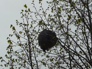
The third tornado came from a different storm, in far southern Oklahoma near the Red River. It also damaged only trees (F1 rating) but was a well-developed tornado that would have been highly dangerous to anyone in its path.

PUBLIC INFORMATION STATEMENT
NATIONAL WEATHER SERVICE NORMAN OK
315 PM CDT WED APR 26 2006

OKZ004>048-050>052-270300-
315 PM CDT WED APR 26 2006

...FINAL DAMAGE SURVEY INFORMATION - CANADIAN COUNTY TORNADOES...

HERE ARE THE FINDINGS OF THE DAMAGE SURVEY OF THE TORNADOES NEAR EL RENO ON MONDAY APRIL 24 2006...

TORNADO NUMBER ONE - 723 PM TO 738 PM THIS TORNADO DEVELOPED 5.5 MILES WEST OF DOWNTOWN EL RENO AND MOVED JUST NORTH OF DUE EAST...ENDING 3.1 MILES WEST-SOUTHWEST OF DOWNTOWN EL RENO.

THE ONLY DAMAGE WAS TO A SMALL GROVE OF TREES. A FUJITA SCALE RATING OF F1 IS BEING ASSIGNED BASED ON DAMAGE TO THE TREES. THE MAXIMUM WIDTH OF THIS TORNADO WAS AROUND 100 FEET.

TORNADO NUMBER TWO - 730 PM TO 739 PM THIS ANTICYCLONIC...OR CLOCKWISE ROTATING...TORNADO DEVELOPED SOUTH OF TORNADO NUMBER ONE...FORMING 5.1 MILES SOUTHWEST OF DOWNTOWN EL RENO AND MOVED EAST...AND THEN SOUTHEAST BEFORE DISSIPATING 5 MILES SOUTH-SOUTHWEST OF DOWNTOWN EL RENO.

F1 DAMAGE OCCURRED TO A HANGAR AT THE EL RENO MUNICIPAL AIRPORT...WHICH SUSTAINED A DIRECT HIT FROM THE DUSTY TORNADO. METAL PANEL WALLS AND THE METAL SEAM ROOF WERE DAMAGED...ALONG WITH SOME INTERIOR WALLS. SEVERAL AIRCRAFT INSIDE THE HANGAR WERE ALSO DAMAGED. THE MAXIMUM WIDTH OF THIS TORNADO WAS AROUND 600 FEET.

$$SMITH/SPEG/STUMPF/BURKE


NWS NORMAN CONTINUES TO GATHER DETAILS ABOUT THE TORNADO THAT MOVED ACROSS SOUTHERN COTTON COUNTY SOUTH OF RANDLETT. INFORMATION SO FAR INDICATES THERE WAS NO STRUCTURAL DAMAGE...ONLY DAMAGE TO TREES...POWER LINES AND FENCES. MORE DETAILS WILL BE RELEASED AS WE GET THEM.

Chase Report by Simon Brewer
Chase Report by Jason Brock of TASC
Chase Report by Mike Hollingshead
Chase Report by Aaron Kennedy
Chase Report by Amos Magliocco
Chase Report by Gene Moore
Chase Report by Jeff Snyder
Chase Report by Bill Tabor
Chase Report by Justin Walker
SPC Storm Reports log

Monday, April 17, 2006

Weather Event #11-Severe Weather and Tornadoes Continue Over Easter Weekend

Friday, April 14, 2006

Weather Event #10-More Signs of Spring

An outbreak of severe thunderstorms developed rather unexpectedly over Iowa, Wisconsin and Illinois on the evening of Thursday, April 13. Several strong, destructive tornadoes touched down across eastern Iowa with at least one fatality confirmed. In southern Wisconsin, widespread hail larger than golfballs caused considerable damage.

KCRG Ch. 9 Photo Gallery
NWS-Davenport Final Report on April 13 Tornadoes
NWS-Milwaukee/Sullivan Hail Pictures from Thursday Night
NWS-Milwaukee Sullivan April 13th Wisconsin Hailstorm
NWS-Green Bay Severe Thunderstorms Pound East-Central Wisconsin
NWS-Green Bay Microbursts in Calumet County
WISC Ch. 3-Madison, WI-Large Hails Pounds Parts of Wisconsin
SPC Storm Reports log

A series of thunderstorms passed over Green Bay from about 10 PM-midnight with copious amounts of lightning and wind gusts in the 30-40 mph range. I set up my video camera on the eastern shore of the Green Bay pointing west/southwest.


Wednesday, April 12, 2006

Spring Arriveth

You know it's spring when...

...first day you can feel comfortable outdoors without a sweatshirt
...there are big flies buzzing around in the weight room again (probably the offspring of the ones that were buzzing around in there until late October last year)
...daffodils, crocuses and Easter bunnies...


...and the final piece of evidence...

...THERE IS A SLGT RISK OF SVR TSTMS FROM THE UPPER MS VALLEY INTO THE GREAT LAKES...

This is for tomorrow. The main risk is for hail from elevated storms, but with strong deep-layer shear they will probably be supercellular and quite photogenic (if they can form discrete cells instead of one giant convective mess). I can't chase because I have class in the late afternoon, but with luck I will at least be able to see a decent thunderstorm, which would be the first since March 11th.

Friday, April 07, 2006

Weather Event #9-April Strikes Again

Reports on April 06-07 Severe Weather Events (Updated April 12, 2006)

Yet another potent extratropical cyclone crossed the United States during this period and interacted with sufficiently unstable air for severe thunderstorms and tornadoes. An F2 tornado hit Washington County, Kansas on April 6th and preliminary reports indicate several destructive tornadoes across Tennssee, Mississippi and Alabama on the 7th. The National Weather Service offices have yet to survey these damage paths, so a lot more information will be forthcoming. Both days also received a "high risk" forecast from the Storm Prediction Center, so more information about them will be available in my archive when that is next updated.

Thursday, April 06:
Little Rock, Arkansas
Topeka, Kansas
Wichita, Kansas
Omaha, Nebraksa
Tulsa, Oklahoma:

PUBLIC INFORMATION STATEMENT
NATIONAL WEATHER SERVICE TULSA OK
500 PM CDT FRI APR 7 2006

PRELIMINARY TORNADO INFORMATION FOR APRIL 6, 2006

TORNADO 1...

AT 349 PM...A TORNADO BRIEFLY TOUCHED DOWN ABOUT 12 MILES WEST NORTHWEST OF HOMINY IN OSAGE COUNTY. NO DAMAGE WAS REPORTED.

TORNADO 2...

AT 703 PM...A TORNADO TOUCHED DOWN APPROXIMATELY 6 MILES NORTHEAST OF HOLLOW IN CRAIG COUNTY. THIS IS ABOUT 3 1/2 MILES SOUTH OF THE KANSAS BORDER. NEAR THE INITIAL TOUCH DOWN...THE ROOF WAS BLOWN OFF OF A MOBILE HOME...THEN THE TORNADO MOVED NORTHEAST ACROSS FIELDS AND THROUGH TREES. NO INJURIES WERE REPORTED. THE OKLAHOMA PATH LENGTH WAS ABOUT 3 1/2 MILES WITH A WIDTH OF ONLY ABOUT 40 YARDS. THE TORNADO HAS BEEN RATED F-0. THE TORNADO CONTINUED INTO KANSAS. ADDITIONAL INFORMATION MAY BE OBTAINED FROM THE WICHITA NATIONAL WEATHER SERVICE OFFICE.

TORNADO 3...

AT 747 PM...A TORNADO WAS OBSERVED BRIEFLY TOUCHING DOWN ON LAKE EUFAULA JUST WEST OF THE DAM. THE LOCATION WAS APPROXIMATELY 4 MILES NORTH OF ENTERPRISE IN HASKELL COUNTY. NO DAMAGE WAS REPORTED WITH THE TORNADO.
Chase report by Mike Hollingshead
Chase report by Mikel Shively
SPC Storm Reports log

Friday, April 07:
Birminham, Alabama
Huntsville, Alabama
Peachtree City, Georgia
Syracuse, Indiana
Jackson, Kentucky
Louisville, Kentucky
Memphis, Tennessee
Morristown, Tennessee
Nashville, Tennsessee
SPC Storm Reports log
Yahoo News article
WTVF Ch. 5-Nashville, TN